How to connect Google Maps to Google Calendar?
Google Maps and Google Calendar are not directly “connected” as separate apps requiring activation. Instead, when you add a location to a Google Calendar event, Google Calendar automatically displays a map preview and related information using Google Maps data. The integration is built in.
How Google Maps integrates with Google Calendar:
When you include a location in a calendar event, Google Calendar:
- Recognizes the address using Google’s location database
- Displays a map preview of that location
- Provides turn-by-turn directions to event attendees
- On mobile, can estimate travel time based on current traffic
- Offers a “leave now” reminder based on traffic conditions
All of this happens automatically once you add a location. No separate setup is required.
Adding a location to an event (integrating with Maps):
Open Google Calendar at calendar.google.com.
Click on an event, or create a new event by clicking Create (the + button).
Click Edit to open the full event editor.
Scroll down to the Location field.
Type a location (address, business name, landmark, or intersection).
Google Calendar recognizes the location and shows a map preview with the address highlighted.
Click Save.
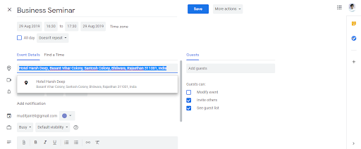
Viewing the map and getting directions:
Open the event in Google Calendar.
Look for the location field, which displays:
- The address or business name
- A small map preview (on desktop and mobile)
- A “Directions” link or button
Click the map or “Get directions” link to open Google Maps with turn-by-turn navigation to the event location.
Google Maps will show current traffic conditions and estimated arrival time.
Mobile: Travel time reminders
On Google Calendar’s mobile app:
Add a location to an event as described above.
Set a reminder for the event (e.g., 30 minutes before).
Google Calendar will estimate travel time to the location based on current traffic.
You will receive a reminder that says “You should leave now to arrive on time” or a similar message based on traffic conditions.
Tap the reminder to open directions in Google Maps.

Sharing location with attendees:
When you send calendar invitations:
Attendees see the location field in the invitation.
If they open the event in Google Calendar or Gmail, they see the map preview and can click for directions.
If they use a different calendar app or email client, they see only the address text (no map).
They can manually search the address in Google Maps if needed.
Why this integration matters:
- Navigation: Attendees do not need to manually copy/paste addresses into Google Maps
- Traffic awareness: You can estimate travel time and leave with enough margin for delays
- Accessibility: All location details (address, map, directions) are in one place within the calendar event
- Mobile efficiency: On your phone, you can navigate to the event location without switching apps
Note about deprecated features:
Older versions of Google Maps had a “My Places > Upcoming Events” feature that would show calendar events on a map view. This feature has been largely deprecated and is no longer reliably available in current Google Maps versions. The primary way to use Google Maps with Google Calendar is through the integration described above (adding locations to individual events).